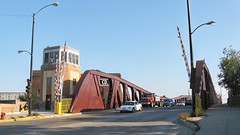
Although it isn't a big local tourist attraction like Navy Pier or the John Hancock building observatory, one of My all time favorite local Chicago landmarks, is this old drawbridge on South Canal Street, located just outside of downtown Chicago Illinois. Painted an oxide red primer colors in recent years, this drawbridge over the Chicago River and many others were once painted in a medium to light gray color.
I am not sure, but I believe that this is the location where the south branch of the Chicago River, becomes the Chicago Sanitary and Ship Canal. Located just to the immediate east of the bridge, is the railroad lift bridge who's right of way leads to 21st Street junction, La Salle Street Station and of course Chicago Union Station.
It is also the location of a local Marina and Yacht Yard for wintertime private boat storage. This is located just north of Chicago's Bridgeport neighborhood on the near southside of Chicago. The Chicago River is maintained at a depth of 22 feet deep for shipping traffic and river navigation.
1 comment:
Hi Eddie,
My initial thought when reading this post is that the start of the Sanitary & Ship Canal would not be at this point, but further west. A check of a map shows the first use of that name at Ashland, which actually looks like a natural demarcation because of the appearance of the waterway after that point and before.
Of course, I'm not citing any official source here.
Post a Comment